Nov. 2022 Science Corner | “Forests to Faucets 2.0: Connecting forests, water, and communities”
Forests to Faucets is an interactive map and report produced by the U.S. Forest Service that aims to identify source watersheds important for drinking water supplies and the potential threats to that supply.
Authors: Erika Mack, Rebecca Lilja, Sally Claggett, Ge Sun, and Peter Caldwell
Interview and story by: Phil Saksa, PhD
Photo credit: U.S. Forest Service
Almost 50% of drinking water in the conterminous U.S. comes from forestland, which only covers about 30% of the land area. In the western U.S. that number is much higher, with over 70% of water supply coming from forests. As a result, it is critical to understand how these watersheds impact and support water supply.
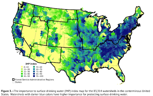
Forests to Faucets is an interactive map and report produced by the U.S. Forest Service that aims to identify source watersheds important for drinking water supplies and the potential threats to that supply. The project lead, Dr. Ge Sun, notes that “it’s really about connecting people to where their water supply comes from, so that when they turn on that faucet at home, they have a better understanding of where that water comes from and how much of that water originates from forests”. Version 2 was published earlier this year, an update from the initial dataset that was produced about ten years ago.
The Forest 2 Faucets data are used to create an index of watershed importance to drinking water, based on population size and the location of water intakes near forested watersheds. “This initiative was really started within the State & Private Forestry arm of the USFS,” mentioned Dr. Sun, “recognizing the value that both public and private forests play in regulating water supply”. The maps and data also provide an indication of Ability to Produce Clean Water, based on land cover changes from forests, which provide high quality water, to other land uses such as urban or developed areas that may result in lower water quality.

As part of the update, “risks from climate change to water supply are newly evaluated”, Dr. Sun said, “which exacerbates other threats to water supply, such as wildfires, pests, and disease.” One of the results that might surprise people based in the western U.S., where wildfire is a widely recognized forest management challenge, is the high risk of wildfire to water supply in the southeast. “While still smaller than western wildfires, larger fires are becoming more common due to increasing drought and the number of dry days in that region” says Dr. Sun. “You can see examples of this from the Chipola Complex Fire earlier this year in Florida and the Lost Cove Fire that occurred around Christmas in North Carolina last year.”
Initial climate change projections show reduced availability of water supply by 2040, extending further by 2090. These results are due in part to reduced precipitation and in part due to increased temperatures, which result in greater water loss from evaporation and vegetation water demand. Dr. Sun looks ahead as his team is further developing this information: “we’ve just started the climate change assessments, and there’s a lot more we can do with the range of model projections for future conditions.”
We look forward to future developments of this incredibly useful dataset and maps, which we at Blue Forest use in part of our project assessment of environmental risks, ecosystem benefits, and potential outcomes of forest restoration projects. We have added it to the tools section of our website, which you can check out here.